Pavement Management Program
Engineering Links
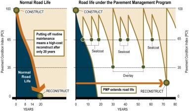
Pavement Management Program (PMP)
The City of Bloomington maintains around 342 miles of city streets. This includes snow removal, crack sealing, street patching, sweeping as well as structural maintenance. For current progress updates: Progress Updates for Current PMP Projects
The City of Bloomington maintains around 342 miles of city streets. This includes snow removal, crack sealing, street patching, sweeping as well as structural maintenance.
PMP is a maintenance plan for streets. Maintenance crews perform the proper maintenance techniques at the optimum time. PMP prolongs pavement life, which reduces costs and assessment rates for property owners.
Three construction techniques are used as part of the PMP program:
- Sealcoat involves spraying a bituminous adhesive on the existing surface. The surface is then topped with small, graded aggregate rock. Excess aggregate is swept off and recycled. This helps protect pavement from oxidation and the effects of moisture. Street segments are typically crack sealed the year prior to sealcoating.
- Mill and Overlay involves grinding off the top layer of surface and installing a new top layer of pavement. This extends the life cycle of the original pavement. Additionally, street segments are typically crack sealed within a year or two of completing a mill and overlay to extend the life of the pavement.
- Reconstruction removes and replaces existing asphalt pavement and aggregate base. Curbs and gutters are installed if necessary.
Information, such as the number of cracks, road thickness and maintenance history, are entered into a database. The database outputs a Pavement Condition Index (PCI) number which is used for budgeting and as a guideline for suggested maintenance. Before any work is performed, the street is carefully inspected and assigned maintenance as appropriate.
Patch and repair
A pothole or small isolated section is cleaned of loose materials and filled. Rubber sealant is placed in cracks which have been thoroughly cleaned and dried. Crack sealing seals out water, which is especially important during freeze-thaw cycles.
Sealcoat
Sealcoat is a wear-resistant coating that protects pavements from oxidation and the effects of moisture. A bituminous adhesive is sprayed on the existing surface and small graded aggregate rock is applied.
Mill and Overlay
Bituminous surface is ground off and a new top layer of pavement is constructed. Milling creates an even surface to ensure a smooth riding surface for the new overlay. An overlay is a structural improvement that renews the street surface and extends the life cycle of the original pavements.
Reconstruction
The entire existing asphalt pavement and aggregate base are removed and rebuilt to current standards. Reconstruction may also involve subgrade soil corrections. For streets that are below current design standards for width, drainage, and curb and gutter, an upgrade may be incorporated.
Trails
There are several maintenance techniques used on trails, ranging from crack seal or fog seal, to removal and replacement of the pavement to current standards.
Construction areas are dangerous!
- Stay away from equipment, materials and trenches.
- Be especially careful to keep children away from these areas.
- Observe posted detours and warning signs.
- Survey stakes are important for project progress; please leave them up for the duration of the project.
Sealcoat
Contractors have many simultaneous jobs and may not be in your area for some time. Bad weather and unforeseen factors often extend the completion date. Drive carefully.
- The street may be rough and have areas where the surfacing has been removed.
- Although the contractor will water streets to reduce dusty conditions, dust may still be a problem in dry weather. Drive slowly to create less dust.
- In wet weather, muddy conditions may exist. If possible, crews will drain or otherwise correct the wet areas.
Before construction
• Mark any sprinkler system that may be buried in the boulevard.
• Remove or relocate electrical lighting and invisible dog fences from the boulevard (right-of-way). The property owner is responsible for relocating or repairing any items that do not have an approved right-of-way permit.
After construction
The contractor will restore the disturbed area to condition equal to that at the time of removal.
• If the disturbed area was sodded, the contractor is responsible for tending and watering the new sod for 30 days after its placement.
• Your sod is only covered under warranty for 30 days after its placement. At 30 days, the City will inspect all sod. However, if you notice any problems, notify the city within 30 days of placement.
• The City is unable to hold the contractor responsible for any problems that are discovered with the sod after 30 days.
Caring for new sod
• New sod will require frequent watering. Water as early as possible (5 - 8 a.m.). This allows sufficient time for the lawn to dry before nightfall and reduces evaporation.
• Do not cut the new sod for about 21 days.
• When cutting the sod, raise the mower deck for the first few times. Cutting too low can cause large accumulations of clippings. This can dry out the sod and increase opportunity for weed germination.
The PMP trails program addresses the design, construction, and maintenance of the City’s 25 miles of street trails and 13 miles of park trails.
Trail segments selected for rehabilitation are designed to meet modern standards, including minimum trail widths and proper geometry. The construction techniques used include crack sealing, fog sealing, or completing reconstruction.
Trails projects do not occur every year. Annual funding amounts are saved until they meet budgeted project amounts.
- Send e-mail and attach document to Engineering@BloomingtonMN.gov
- Para pedir este documento en otro idioma, envíe un correo electrónico y adjunte el documento a Engineering@ BloomingtonMN.gov
- Si aad u codsato dukumeentigan oo ku qoran luqad kale, fadlan e-mail u soo dir oo ku soo lifaaq dukumiintiga Engineering@ BloomingtonMN.gov
PMP candidates
| STREET NAME | START | END |
| West Bush Lake Road | West 87th Street | Highwood Drive |
| Park Knoll Circle | Terminus West | West Bush Lake Road |
| Xylon Circle | Terminus South | West Bush Lake Road |
| West 83rd Street | West Bush Lake Road | Wyoming Avenue |
| Wyoming Avenue | Terminus South | West 83rd Street |
| West 91st Street | Vincent Avenue | Upton Avenue |
| West 88th Street | Logan Avenue | Humboldt Avenue |
| West 87th Street | Logan Avenue | Humboldt Avenue |
| Logan Avenue | West 88th Street | West 87th Street |
| James Avenue | West 88th Street | West 87th Street |
| Irving Avenue | West 88th Street | West 87th Street |
| Humboldt Avenue | West 90th Street | West 86th Street |
| *Fremont Avenue | West 92nd Street | West 90th Street |
* Constructed with the 2026-501 North Central Sanitary Sewer Capacity Improvement Project
Stanley Ave sidewalk project will also be built with the 2026-101 PMP Project
| STREET | START | END |
| West 102nd Street | Nesbitt Avenue | Normandale Boulevard (CSAH 34) |
| Johnson Road | Heritage Hills Drive | Kell Avenue |
| Oxborough Avenue | West 81st Street | American Boulevard W. |
| West 80th Street Circle | West 81st Street | American Boulevard W. |
| West 107th Street | Penn Avenue | Morgan Avenue |
| West 101 ½ Street | France Avenue (CSAH 17) | Drew Avenue |
| Drew Circle | West Terminus | Drew Avenue |
| Drew Avenue | West 101 ½ Street | North Terminus |
| Chowen Avenue | Drew Avenue | W. 100th Street |
| West 100th Street | Chowen Avenue | Beard Avenue |
| Beard Avenue | West 100th Street | Beard Curve |
| Beard Curve | Beard Avenue | Beard Avenue |
| West 98th Street | France Avenue (CSAH 17) | Penn Avenue (CSAH 32) |
| Morgan Avenue | South Terminus | American Boulevard |
| Hopkins Road | Lyndale Avenue | Hopkins Circle |
| Mission Circle | West Terminus | Mission Road |
| Blaisdell Circle | Mission Road | South Terminus |
| Pleasant Avenue | West Old Shakopee Rd (CSAH 1) | West 95th Street |
| West 93rd Street | Lyndale Avenue | Grand Avenue |
| Grand Avenue | West 93rd Street | West 90th Street |
| Pillsbury Avenue | West 92nd Street | West 90th Street |
| Blaisdell Avenue | West 92nd Street | West 90th Street |
| Wentworth Avenue | South Terminus | West 86th Street |
| 5th Street | American Boulevard | East 78th Street |
| Chicago Avenue | East 80th Street | East 78th Street |
| East 80th Street | Chicago Avenue | 12th Avenue |
| East Old Shakopee Road (CSAH1) | 24th Avenue | 34th Avenue |
| 34th Avenue | East Old Shakopee Road (CSAH1) | American Boulevard E |
| American Boulevard E | 34th Avenue | East Terminus |
FAQs
Roads are compared by using a Pavement Condition Index (PCI) which is a scale of 0-100 with 100 being a brand new road and 0 being a fully deteriorated back to gravel road.
Information, such as the number of cracks, road thickness and maintenance history, are entered into a database. The database outputs a Pavement Condition Index (PCI) number which is used for budgeting and as a guideline for suggested maintenance. Before any work is performed, the street is carefully inspected and assigned maintenance as appropriate.
To obtain this PCI data, Maintenance staff walk one-third of the City streets every year to inspect the pavement.
Public Works Engineering and Maintenance staff drive around in the Spring to finalize details for the next year, while also driving to examine potential street project areas 2-4 years out.
| PCI | Description | Probable Maintenance |
| 100 | Newly Constructed | None |
| 99-66 | Adequate | Sealcoat |
| 65-36 | Marginal | Mill and Overlay |
| 35-1 | Problem | Reconstruct |
The Public Work’s Pavement Management Program has reduced the overall cost of keeping our streets in good condition. The following shows how the work is funded:
Sealcoat
City's General Fund
Overlay
City’s Infrastructure Replacement Fund Distributed by the State of Minnesota from fuel sales tax and license fee tabs along with Franchise fees
Reconstruction
City’s General Fund and Assessments
Single- and two-family residences pay only 25 percent of their portion of a project through assessments;
commercial, industrial, or multifamily residences pay 50 percent of the costs. Other funding sources make up the difference.
The area in front of your home which is occupied by street, public utilities (sanitary sewer, water and storm sewer), private utilities (electric power, telecommunication and gas) and other necessary items such as street signing, snow storage and lights is public right-of-way.
A typical right-of-way width in residential areas in Bloomington is 60 feet. (Not all the right-of-way widths are the same and yours may vary from this width. The project engineer can confirm the width for you.) Since a typical residential street width in Bloomington from 32 feet to 36 feet and is centered in the right-of-way approximately 12 feet to 14 feet of public right-of-way exists on either side of the existing streets.
The actual disturbed area will vary, but a good assumption would be that the 12 feet to 14 feet of public right-of-way will be disturbed. For actual limits please contact the project engineer.
Signs will be posted allowing local traffic only on the streets under construction. Residents who live on these streets will have access to the street throughout construction.
The overlay project is anticipated to start in May with the reconstruction project following shortly thereafter in late May-early June. Both projects are anticipated to be substantially complete and open to all traffic in the fall.
The City Council has approved a number of policies in conjunction with the Pavement Management Policy. One policy is: All new street construction and street reconstruction in Bloomington will include concrete curb and gutter. This is for a number of reasons:
- Provide a stable maintenance edge for plowing and sweeping operations.
- Reduce plow damage to yards and mailboxes.
- Protect the edge of the bituminous surface from deteriorating.
- Channel storm water runoff away from street.
- Reduce erosion from boulevards/lawns.
- Define roadway limits.
Council also has approved street width with the standard residential street width being 32' face of curb to face of curb. The policy allows deviation from the standard considering factors such as traffic volumes, emergency vehicle access, drainage and special situations. Other policies include that streets without curb and gutter are not eligible for overlay. The City Council and Staff schedule neighborhood meetings with the impacted properties to begin discussion about construction issues, identify additional concerns and propose possible solutions.
After the Public Hearing and discussion, the City Council approves streets for reconstruction and orders the improvement.
What is a street made from?
Asphalt cement and aggregate rock are mixed, heated and spread on a base of gravel.
What will my boulevard look like after?
Items installed under a permit will be restored accordingly. If sodded, property owners will need to water the new grass.
Will my mail or trash be disrupted?
No. Regular services will not be affected.
How will the water and sewer lines be affected?
Water, sanitary and storm lines will be checked and repaired as needed.
What about my irrigation system?
If the existing system extends into the new road, this project will cut the lines and reinstall the heads behind the new curb. The City will not extend any lines located in the right-of-way that were placed without a permit.
We have a low spot in front of the house where water does not drain. Will it be fixed?
Yes, but please notify the Engineering Department to confirm we are aware of the situation.
Can I get into my driveway during construction?
Yes, except if curb and gutter concrete is replaced. Concrete requires one week to cure. Please contact your project manager to inquire about alternate parking during this time period.
How long will construction take?
Approximately two weeks before construction, you will get a notice with important information about the project. Large projects can take the entire summer (approximately two to four months).
Will the sidewalk be repaired or replaced?
Sidewalks that pose a tripping hazard will be repaired or replaced.
PMP Residential Street Policies
Policy S-A-1
Issued: 11-4-02
Revised:
B618 curb and gutter will be used on all new residential street construction and on all residential street reconstruction projects including where existing curb and gutter is not present.
Questions:
Any questions regarding this policy should be referred to the City Engineer.
Expiration:
This policy will begin with the 2003 construction season.
Background:
The Traffic & Transportation Advisory Commission (T.T.A.C.) and City staff were directed to review residential street policies for the Pavement Management Program. A part of this review included curb and gutter design and use. T.T.A.C. endorsed a policy of B618 curb and gutter on all residential streets.
Policy S-B-1
Issued: 11-4-02
Revised:
Policy Statement:
Existing residential streets without curb and gutter will be reconstructed to a face of curb to face of curb width as follows:
| From Existing Width: | Reconstructed to Width: |
| 28’ or less | 28’ |
| 29 – 30’ | 30’ |
| 31’ or greater | 32’ |
Staff may vary from this width for unique situations. Factors for consideration in selecting street widths typically include but are not limited to the following:
- transitions to adjacent curbed sections,
- on-street parking demand,
- right-of-way limits,
- obstructions such as trees or drainage structures,
- terrain,
- construction costs,
- Average Daily Traffic (ADT),
- roadway geometry,
- emergency vehicle access,
- adjacent land use, and
- current width.
Questions:
Any questions regarding this policy should be referred to the City Engineer.
Expiration:
This policy will begin with the 2003 construction season.
Background:
The Traffic & Transportation Advisory Commission (T.T.A.C.) and City staff were directed to review residential street policies for the Pavement Management Program. A part of this review included street widths. T.T.A.C. endorsed a policy of reconstructing existing residential streets, less than 28’ wide, without curb and gutter at 28’ – 32’ in width. .T.T.A.C. also endorsed a policy of reconstructing existing residential streets, where the predominant width of asphalt is 28’ wide or greater, without curb and gutter, at 28’ – 32’ in width with B618 curb and gutter.
Policy S-B-2
Issued: 11-4-02
Revised:
Policy Statement:
Existing residential streets with curb and gutter will be reconstructed at the current width when reconstructed.
Questions:
Any questions regarding this policy should be referred to the City Engineer.
Expiration:
This policy will begin with the 2003 construction season.
Background:
The Traffic & Transportation Advisory Commission (T.T.A.C.) and City staff were directed to review residential street policies for the Pavement Management Program. A part of this review included street widths. T.T.A.C. recommended that residential streets with curb and gutter be reconstructed in 2003 at their existing width.
Policy T-P-1
Issued: 11-4-02
Revised:
Policy Statement:
When reconstructed, parking shall be prohibited on residential streets as follows:
| Street Width | Parking Prohibited |
| Less than 24’ | Both sides |
| 24’ through 28’ | One side |
Questions:
Any questions regarding this policy should be referred to the City Engineer.
Expiration:
Implementation on reconstructed residential streets will occur during 2003.
Background:
The Traffic & Transportation Advisory Commission (T.T.A.C.) and City staff were directed to review residential street policies for the Pavement Management Program. A part of this review led to a recommendation by T.T.A.C. to restrict parking to one side on streets being reconstructed to 24’ to 28’ in width and prohibit parking on both sides of streets on streets being reconstructed to less than 24’ in width as measured face to face of the curb.