
Waters of Bloomington

Cyanobacteria, commonly known as blue-green algae, is seen all across the state of Minnesota. When blooming, these organisms produce toxins that can cause harm to humans and animals. Blooms normally begin to occur during hot summers, especially if there is ample rainfall.
During a blue-green algae bloom, the water may look like it has spilled green paint on the surface. Unlike duckweed, which is a plant that floats on the surface of the water, blue-green-algae looks as if it is mixed into the water. Harmful algae blooms are most likely to occur during warm weather in shallow, nutrient-rich waters. It is best to avoid contact with these waters if you suspect there is an algae bloom. Always remember, when in doubt, best keep out!
For more information, visit:
The Engineering Division routinely inspects construction sites throughout Bloomington to ensure that effective erosion control methods are being used to prevent sediment from getting into local water bodies. Each construction site typically has it's own erosion control plan, which is used as a guideline to prevent storm water pollution.
Principles of Erosion Control
The six basic principles of erosion control protect our ponds, streams and wetlands, the water bodies that link our storm sewer system to the Minnesota River.
- Minimize both the area and time of soil disturbance at the site, throughout the duration of the project.
- Manage storm water moving across the site. By reducing the velocity and volume of the runoff, the impact to exposed soils will be reduced.
- Install erosion and sediment control measures early and keep them well maintained, especially important during months that receive heavy rain events.
- Keep sediment from leaving the site. Slowing down the runoff before it leaves the site will prevent sediment from getting into environmentally sensitive areas.
- Establishing temporary vegetation by seed will reduce erosion by up to 90%.
- Successful plant establishment by:
- Good Planning
- Knowledge of soil characteristics
- Good seedbed preparation
- Timely planning
Laws to Prevent Erosion
Many laws, including 1972 The Clean Water Act, require preventing water pollution. Recently, the National Pollutant Discharge Elimination System (NPDES) required permits of Municipal Separate Storm Sewer System (MS4) owners that discharge storm water, Bloomington included.
In March 2003, Bloomington submitted a Storm Water Pollution Prevention Program to the Minnesota Pollution Control Agency (MPCA) which outlines our efforts to educate and encourage effective erosion control at construction sites in Bloomington.
Information and Facts
For information on the State of Minnesota's groundwater, visit the MPCA's webpage:
To learn some facts about groundwater in Minnesota, visit the following MPCA webpage:
To watch videos and see graphics, by the MPCA, showing how groundwater moves, visit the following webpage:
State Agency Roles
While groundwater plays a role in how the City of Bloomington manages water resources, the City does not have jurisdiction over groundwater management. The following explains how jurisdiction on groundwater is spread across the State:
- Minnesota Department of Natural Resources: availability and ecological impacts
- Minnesota Department of Agriculture: agricultural pesticide and fertilizer contamination
- Minnesota Pollution Control Agency: industrial contamination
- Minnesota Department of Health: drinking water supply

There are more than 500 bodies of water in Bloomington. they range from small ponds to large lakes. Most of these were here long before the City of Bloomington was incorporated. The City works hard to ensure that these waters and the ecology they support are treated and managed in a way that promotes ecological resiliency, adaptability, and ecosystem health.
Most of the lakes and ponds in Bloomington are considered shallow water systems. These are unique systems that support a complex ecology. One way you can help keep these waters healthy and clean is learn how they function. Check out this video made by the Ramsey-Washington Metro Watershed District to learn about shallow water lakes!
Recreation
There are many recreational opportunities within, and alongside, the Lakes and ponds in Bloomington.
- Click here for a complete list of Bloomington parks
- The Hyland Lake Park Preserve is managed by the Three Rivers Park District. Click here to visit their website.
Remember, when interacting with a body of water, take precautions not to spread aquatic invasive species. Click here for information on how to prevent the spread of aquatic invasive species.
Stormwater Pond Management
The majority of ponds in Bloomington are considered stormwater ponds. This means that pipes connect them to the City’s stormwater infrastructure network. Historically, most of these ponds were not connected to one another. Back then, the water that flowed into them was cleaned by the nearby forests or meadows.
Now-a-days, when it rains, because of the many roads, sidewalks, roofs, and other impervious surfaces, water moves very quickly. Without the historic forests and meadows, the water is able to pick up things on the ground, like dirt, leaves, and trash. It then carries all this stuff into stormwater drains which flow into ponds. That means, anything that was picked up by the water as it moved over impervious surfaces ends up in our ponds. This is a leading cause of water pollution in urban areas.
Check out this video to learn more about how Bloomington samples water quality:

Why So Green?
Plants and algae in ponds and lakes are a common concern for residents. There are types of plants that are problematic and there are plants that are good. In any case, there are always going to be plants. Click the link below for more information on aquatic plants and management options.
Visit the City of Bloomington's permit portal to access permit applications, planning applications, zoning verification letters, encroachment agreements, easement and right-of-way vacations and wetlands permits.
Some projects will require permits from other agencies, especially those that are nearby or impacting water resources. Check with your local watershed district for more information.
Pond and Vegetation
Plants are a fundamental part of ponds. To understand how to best manage plants in ponds, people must set expectations that respect the life in a pond and considers the complex mechanisms of that form a pond’s ecosystem.
The Pond Ecosystem: There are three main categories used when measuring the health of an ecosystem:
- Resiliency – Capacity of a system to take on disturbance or stress and still remain essentially the same. High resiliency means that an ecosystem is tough and low resiliency means it is fragile.
- Adaptability – How well the parts of a system can reorganize in response to change. For example, as the climate warms, the species of trees in a forest might change but the forest remains.
- Transformability – The ability of one type of ecosystem to turn into a completely different ecosystem. If water is drained from a pond, it will become a wetland – same place but different ecosystem.
A pond’s ability to be resilient and adaptable depends on the complex web of interactions between biotic and abiotic factors. Abiotic means all the parts that are not alive. This includes things, like chemicals, landscape and weather. Biotic refers to what is alive, like fish, bugs, plants and birds.
Biotic and abiotic factors are like cards in a deck. In a card game, a good player knows that, to win, they must play their hand based on the cards dealt and not based on cards they want. In the same way, every pond should be assessed and managed based on that specific pond and not on an idea of what a hypothetical pond should be.
Generally, a pond can exist in a few different dominance states. Each one is resilient and resists flipping to a different state. Here is a look at four common dominance states of ponds:
Clear Water Vs. Turbid Water
Clear water ponds tend to be dominated by submerged vegetation because sunlight can shine easily into the water. The vegetation helps soak up nutrients and lock in sediments. The many plants help fish and other animals.
Turbid water is murky and dark. Sunlight cannot shine very deeply into the water so vegetation has a hard time growing. This allows nutrients to be available and can lead to algae blooms and bad smells.
Duck weed dominant VS. Submerged Vegetation Dominant
Duck weeds are small plants and are native to Minnesota. They can start to dominate ponds by blocking sunlight from reaching submerged plants. Bad smells can occur when dying duckweed start to decompose.
Submerged vegetation dominated systems have clear, open water. The submerged vegetation takes away nutrients from duckweeds, their roots lock in bottom sediment and they create great habitat for wildlife, like fish and insects.
Management
A pond in an urban landscape receives far more nutrients than a pond in the wilds of the natural world. In urban areas, storm sewers transport water from roads and other impervious surfaces directly to ponds. How an urban pond is managed, must take this into account. By far, the best way to improve the health of a pond and create a healthy, aesthetically pleasing plant community is to stop nutrients from getting into the pond.
Yard Waste Keep leaves, grass and other yard debris out of ponds. An important way to do this is preventing yard litter from going into storm drains because those often outlet directly into a pond. Keep it off of roads!
Buffers Native plant buffers surrounding a pond protect the pond by cleaning water flowing over land and stabilizing the shoreline. The native vegetation also provides important habitat for both insects and animals. Don’t mow to the water’s edge!
Herbicides
Herbicides kill plants. By doing so, they destroy a foundational piece of a pond’s ecology. Without submerged vegetation, ponds are more susceptible to be in a turbid or duckweed dominated state. Treating a pond with herbicides is not a good long-term management solution because killing plants each season makes it more likely that the pond will return to an unwanted state the following year. For example, duckweed dominance is a common reason for herbicide use. However, herbicides also kill the submerged vegetation that would otherwise compete with the duckweed for nutrients. Without competition from submerged vegetation, a pond is more likely to be in a duckweed dominated state.
Herbicides come with some benefits. They are particularly helpful in managing aquatic invasive species. Removing invasive species with herbicides, combined with a greater restoration initiative, can be a helpful tool to restore a pond ecosystem. It is also possible to use herbicides in spot treatments for recreation purposes and not substantially reduce the resiliency of a pond’s plant communities.
Using herbicide to get clear, open water destroys much more than just the green you can see on the surface. A better way to manage vegetation is to reduce nutrients from reaching the pond. In this photo, a City staff member takes a water sample to test for nutrient levels. Data like this helps the City make positive management decisions to increase pond resiliency and adaptability.

Nine Mile Creek
(map coming soon)
If you want to learn more about Nine Mile Creek, please visit:
Minnesota River
(map coming soon)
If you want to learn more about the Minnesota River, please visit the following websites:
The City of Bloomington crosses the boundaries of four watersheds:
Each watershed is managed by an independent agency, either a watershed district or watershed management organization. If you are looking to do a construction project, you may need a permit from the appropriate watershed district.
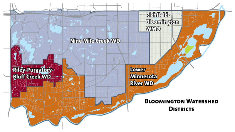
Bloomington residents can find their watershed district using an interactive map.
Find out more information on watersheds across Minnesota at mnwatershed.org or the MN Dept of Natural Resources website.

Learn more about wetlands through the MN DNR's website below
Water Quality
Water and ecosystem quality is monitored throughout the City. The information gathered helps to make management decisions and improves our understanding of each individual water body.
Health of Bloomington's Ponds and Lakes Reports
Check out the City's pond and lake health report for more information on our water quality monitoring program and its results.
Water Resources Management Plans
ATTENTION: Notice of Adopted Updated Local Surface Water Management Plan Effective June 25, 2018
Notice is hereby given the Bloomington City Council adopted an updated Local Surface Water Management Plan on Monday , June 25, 2018. The Local Surface Water Management Plan has been developed to meet local watershed management planning requirements of the Metropolitan Surface Water Management Act (Chapter 103B) and Board of Water and Soil Resources Rules 8410. It has also been developed to be in conformance with the requirements of local Watershed Management Organizations and Districts, Metropolitan Council requirements, Hennepin County goals, and applicable State and Federal laws. The updated Plan includes updates to the city’s land and water resource inventory, goals and policies, problems and corrective actions, implementation program, financial considerations, and amendment procedures.
This document and its referenced literature are intended to provide a comprehensive inventory of pertinent water resource related information that affects the City and management of those resources. The document that follows is the current Local Surface Water Management Plan used to determine city stormwater requirements for permit applications and development reviews submitted after June 25, 2018.
Executive Summary-
Introduction and Purpose-
Land and Water Resource Inventory-
Establishment of Goals & Policies-
Assessment of Problems & Corrective Actions-
Implementation Program-
Financial Considerations-
Amendment Procedures-
Appendices-
What is the Plan?
The City of Bloomington finished its Wetland Protection and Management Plan in June 1997. The Plan is one of the first of its kind for cities in Minnesota. It presents a comprehensive inventory and study of the City's wetlands. The City prepared the Plan as a requirement of a larger plan they are currently working on, the Comprehensive Surface Water Management Plan. The City proposes to finish the Comprehensive Surface Water Management Plan by mid-1999. The overall goal of both plans is to provide a detailed framework to address the City's surface water issues.
Why was it needed?
Wetlands were a part of the landscape in Bloomington long before the first human being arrived in the area. They are part of a dynamic natural system that changes constantly. This system has changed much more rapidly due to human influences. Society has been slow to recognize the benefits that wetlands offer and the impact that centuries of human disturbance have had on wetlands and the larger ecosystem. This plan was prepared as a means of slowing or halting the wetland disturbances caused by human activity
This Wetland Protection and Management Plan meets the requirements of Minnesota Rules, Chapter 8420, part 8420.0650. The plan is consistent with the pertinent goals and policies of the watershed districts and the watershed management organization that have jurisdiction in portions of the City. It also addresses the requirements of Hennepin County and the Metropolitan Council.
Why are wetlands important?
One must understand why it is important to preserve wetlands before one can see the need for the recommendations presented in this plan. A healthy wetland can perform many beneficial functions:
- It can serve as a filter to absorb polluted surface water runoff before it enters lakes or creeks.
- A wetland can store water; thus providing flood protection in times of heavy rainfall and a source of groundwater recharge.
- It provides a home and a source of food for many types of native and migratory birds and wildlife.
- Wetlands provide numerous recreational and educational opportunities.
- In some cases, wetlands even provide commercial benefits, such as wild rice production.
The ability of a wetland to perform particular functions is often directly related to the degree of human influence on the tributary drainage area of a wetland.
What is in the Plan?
Wetland inventory
City staff inventoried approximately 300 wetlands in Bloomington. Wetlands located in or below the Minnesota River Valley were not included. The City ranked wetlands based on their functions and values, how they are managed, and their susceptibility to storm water and snow melt runoff. The plan recommends specific actions to be taken to provide for appropriate management of the wetlands in the future. The Plan also explains the processes used to conduct the inventory and the City's wetland classification system.
History of Bloomington wetlands
The Plan presents a brief history of Bloomington wetlands. Human interference, including agriculture and development, has caused the disappearance and degradation of many of the City's wetlands over time. The status of wetlands in Bloomington from the time of Pre-European contact to the present is discussed.
Assessment of needs for each wetland
Each wetland was inventoried and studied to address specific needs. This was done on a sub-watershed, or drainage area, basis. The Plan provides a general description of each of the 20 sub-watersheds that have wetlands, along with an overview of wetland quality and a summary of recommendations. Specific recommendations for each wetland in a sub-watershed are presented in a tabular format.
Existing City policy/ordinances for Bloomington
The Plan reviews various City policies, ordinances and programs that already exist to address wetland issues. Recommendations for changes or the additions to these policies, ordinances or programs are discussed in order to facilitate implementation of the Wetland Protection and Management Plan.
Recommendations
The Plan discusses the recommendations for capital improvements and the reasons for them. The Recommendations section also discusses the need for operation and maintenance of infrastructure facilities.
Implementation Program
The Implementation section explains the prioritization of recommendations, the implementation schedule, and the estimated cost of each project or program. It also lists the divisions within the City that would be responsible for implementation of various portions of the plan and provides a list of possible funding sources for various plan components.
Where can I view the Plan?
Copies of the City of Bloomington's Wetland Protection and Management Plan can also be found at:
- Bloomington City Hall, 1800 West Old Shakopee Road
- Public Works Building, 1700 W. 98th Street
- Bloomington Public Libraries
The Penn Lake Management Framework was developed to guide the City of Bloomington’s efforts to restore and maintain a healthy ecosystem in Penn Lake and its watershed. The Framework provides a structured process for setting goals, prioritizing projects, and adapting management over time, with a strong emphasis on community participation and scientific monitoring.
The Framework establishes a five-year Management Pathway that identifies priority actions and projects. This process is organized around four criteria: community inclusion, infrastructure planning and maintenance, regulatory coordination with partners such as Nine Mile Creek Watershed District, and monitoring to track ecological change and management effectiveness.